Feeds:
Posts
Comments

Archive for September, 2009

Chattahoochee RR Bridge

Recently accessed a couple of CW frames from the National Archives . This is looking north towards the RR bridge crossing the Chattahoochee River from Boltonville, circa post-1864.  Note the scarcity of trees and distances.

south

National Archives, Atlanta Battlefields, 1864

2National Archives, Atlanta Battlefields, 1864

Caption reads: “Rebel Fort (New Federal No. 7 of new lines) Atlanta, looking towards Chatt. RR (north) Battery M. 56 U.S. Artillery with Gen. Sherman in back ground.”

Read Full Post »

In light of the fact that most flood related losses are uninsured, the question of what, how, and when Federal assistance may come into play will quickly become crucial.  Once Gov. Perdue’s request for Georgia county disaster designation is approved (likely), the degree of response will likely filter through FEMA (Federal Emergency Management Agency).  Getting to the personal loss level and applications thereto, one should begin to devise documentation, evidence of losses, property descriptions, etc. in anticipation of what will be a tedious and  (likely) frustrating and time consuming path. Unfortunately, individual need-timing doesn’t match off with assistance timing…

Neither is it  a “blank check”  process,  and one should begin immediately to understand the implications of, and identity of, whether one lives in a “designated flood plain” and drafting submissions. Remember, it’s not going to be a “claim,” it will be an “application” – which can go either way if not prepared, and is a low cost loan, not a grant…  Further, a really key point buried in FEMA guidelines of  “when not available” is  The damaged home where you live is located in a designated flood hazard area and your community is not participating in the National Flood Insurance Program. In this case, the flood damage to your home would not be covered, but you may qualify for rental assistance or items not covered by flood insurance, such as water wells, septic systems, medical, dental, or funeral expenses. (ref)

flood

You can locate your neighborhood by using the FEMA mapping site. First enter state, county, and community, be sure to note your zone map (Vinings is 13067C0227G) – find according to number. You’ll need a future reference to it. All of Vinings along the river is Zone A (100 year flood plain – which gives you a 1 in 4 likelihood of a flood). X  corresponds to areas outside the 100-year flood plains, areas of 100-year sheet flow flooding where average depths are less than 1 foot, areas of 100-year stream flooding where the contributing drainage area is less than 1 square mile, or areas protected from the 100-year flood by levees.  No Base Flood Elevations or depths are shown within this zone. So one can see the need to get to speed on what this means on an individual case uncovered by flood insurance.

Couple of other helpful prep links to assistance:

FEMA Q & A

familiarity with Flood Insurance, Plains, and Losses

Read Full Post »

Vinings Flood 09-23

fp-flood_257024c

from AJC.com 9/22

Due to the interest (over 250 hits yesterday) on the Vinings flood stretch (Cochise Dr., Paces Ferry, Canoe commercial center, and Paces Ferry Dr.), went back and checked this morning – the river is out and back within banks.  No water.  However, a silent dark brown muck is on everything up to about 5 or six feet.

My experience of working in the marine industry during Hurricane Andrew (92′) in Miami, and on the ground in Gulfport, MS. after Katrina with the Red Cross, are offered relative to returning to flooded property.

1. Caution – flood waters are a conduit of bad stuff. There are going to be snakes, ants, flies, mosquitoes, and possibly rodents (even a dead fish or two)  in and around flooded properties.  Also the potential for live electrical lines and gas leaks. Treat standing water as contaminated. Don’t rush access, entry, and begin removal/clean-up without progressively evaluating hazards. “Clear” potential of infestation and utility issues before beginning cleanup.

2. Children and pets – Leave them elsewhere for the time being to avoid potential for injury.

3. Generators –If no, or questionable, electricity and generators are going to be used for power – place away from structures. There have been incidents of “housing” generators in the  garage that lead to an entire family being asphyxiated from fumes.

4. Document (digital camera) all damages before beginning cleanup (insurance and possibly future FEMA assistance).

5. Help – several heads-up:  Keep initial removal and recoveries to family and known friends. Offers of help from unknown persons might be ok, maybe not – limit the latter to specific tasks and not carte blanc access to where valuables may be.  Second, do not rush to contract with third parties to do anything structurally. They’re going to be soliciting everywhere… and unless recommended, local, licensed, insured, and vetted – hold off with the excuse of “not there yet” and take a phone number.

more suggestion… 

Any assistance or need, which someone would like posted, can be  forwarded to me by e-mail: bleufalcon@aol.com

Read Full Post »

Vinings Flood 09

When I was a kid, we used to go down and watch the floods at the river bridge (1950’s), after a heavy rain – and thought would never see such again… until this morning.

Canoe2

                                       More Pictures

* Chattahoochee River – The river’s level near Vinings was at 27.36 feet before daybreak Tuesday after cresting at 28.1 feet overnight. Flood stage is 14 feet, and anything above 20 feet is considered “major” flooding. The river was expected to slowly recede, falling below flood stage on Wednesday. The level overnight was the second highest on record, exceeded only by a crest of 29 feet in 1919.

Read Full Post »

Vinings ?

This is a U-tube video that says “Vinings, Georgia,” but not sure I see what one should be seeing to be… See what you think.  Oops, figured it out…. comes in from the North side over the river, then around Cochise Dr. ridge, in over down town (tracks on the right), then out over Paces Lake.  Still pretty cool. (you can go to the small icon in bottom right to go full screen, or go to U-tube – Vinings, Georgia, if better to view)  One can also check for other cities for a fly over.  Good grief…

Read Full Post »

Paces Ferry Article 1911

Paces Ferry really started it’s lavish profile in 19-teens, in which this article (AJC 1911) was a primer for the auction of property known as “Tuxedo.”  A little loose history is bestowed, i.e. “Standing Peachtree on Paces Ferry,” and “providing shade for many a Cherokee wigwam…” – not.

pf1

Read Full Post »

Vinings History Release

I’m opening up some Picasa galleries of images, maps, reference, etc. on Vinings History (approx 240 so far) as open source – for those interested in, or doing their own research on various historical subjects. Some have been tagged, and some remain to be. Will try to get to all of them.  May not be able to download, as Picasa has some built in permissions, however, if there is a need to do so, one can ask…

Vinings

 more Vinings

 Vinings Revisited

  Maps and Reference

Standing Peachtree

Read Full Post »

Can Feel the Panic Already…

Big boost for Atlanta-Chattanooga rail

$14.2 million study grant gives the high-speed rail project new life 

AJC article 9/11

Read Full Post »

Standing Peachtree

tree


There has been a six month focus study on the perplexing history of what is called “Standing Peachtree”-the origin point of both Atlanta and street.  While not complete, for lack of archaeology conclusions, there is a more fundamental insight into how the name may have had some precedent, even before the later recounts of Wash Collier and Eugene Mitchell in the early 1900’s (i.e. “a lone peachtree known to be growing on a large heap of dirt“).  Wash Collier said the location used to be “known by some Indian name…”  What possibly was that?

Essentially,  it appears there were two phases of  significance. (1.) the lesser known phase of mound-builder presents as a remote small Chiefdom, which extended to both sides of the Chattahoochee and agriculturally dotting both directions on the river before 1500’s,  abandoned (likely due to European disease introduction) soon after the Desoto Expedition through Georgia in 1540. This phase likely did not have a name associated with peaches.  (2.) a resurgent location seasonally used for trade and exchange by both Upper and Lower Creek confederations in the 1700’s with white settlements in South Carolina and coastal Georgia. This too diminished as white settlement encroached, so that by the time Lt. Gilmer built “Fort Peachtree” in the early 1800’s, the area again was a distant fringe of Creek territory.

It was likely in this 2nd phase that there was trader introduction of “Peaches” (China to Europe to US), or the English term for an Indian fruit known as the “May Apple,”  (English, and close to the same species) likely being orcharded in the vicinity.

There were several Creek Indian locations (AL,NC,LA, and TX) that were called “Peachtree,” in late 1700-early 1800 English references, besides our “Standing Peachtree.” However, the suggestion is that this point on the Chattahoochee may well have been known by two names: “Pakanahuili” by the Upper Creeks to the west, and “Pucknawheatly” by the Lower Creeks from around Columbus, Georgia.  Both referencing the “peach or May apple” in two language fractions, before our later and popular origin.

If interested, the deeper basis of theory can be read  here.

Read Full Post »

Vinings Rd

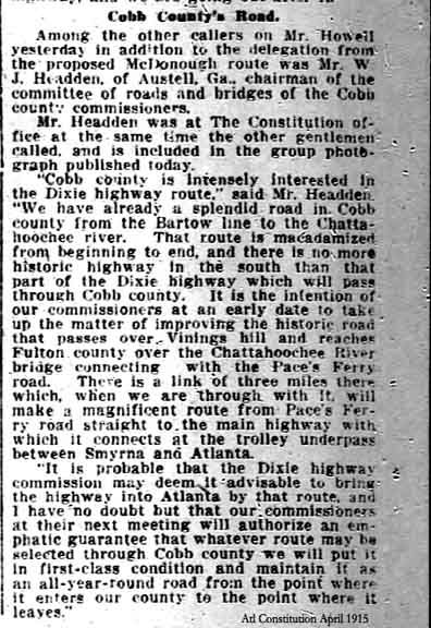
When the Dixie Highway was improved in the early 1900’s, it was determined that the route into Atlanta should be “diverted” through Vinings and Paces Ferry Rd to better impress the traveling public approaching Atlanta via the manions dotting (now) West Paces Ferry Road to Buckhead:

cobroads

Read Full Post »

Older Posts »